Multitemporal analysis of vegetation cover change in the management area "Los Números" Guisa, Granma
Main Article Content
Abstract
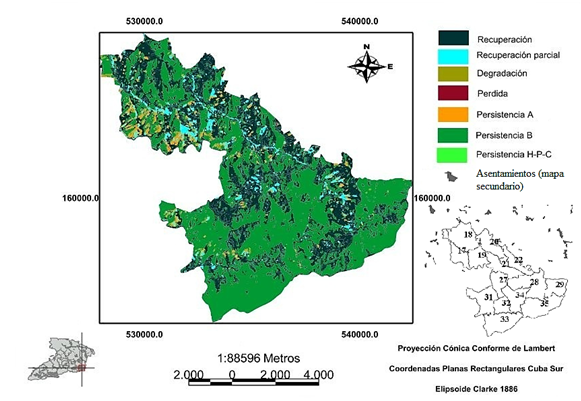
The work was carried out in the area of "Los Números", Guisa municipality, Granma province, Cuba. This area forms one of the largest rural councils in the territory, where forestry plays a fundamental role, with an impact on more than 80% of the area. The objective of the research was to evaluate the spatial-temporal dynamics of the change in vegetation cover that occurred between 1986 and 2016 in lands under a forest management regime. To this end, through the supervised classification of Landsat 5 and Landsat 8 satellite images, the cover was catalogued into four occupation categories (forest; shrub; grassland or crop; and naked-soil). Information from the forest management project of the Granma Agroforestry Enterprise was used, where the characteristics of the plots are presented. The result was that, during the period analyzed, 20.91 km² of shrub areas and 6.38 km² of grasslands, pastures or crops decreased, as well as 6.65 km² of naked soil, while 33.94 km² of forest clearly represented the advance of the forest cover limit. In terms of the persistence of the forest category, the Mountain Rainforest and Pine Forest formations were the most distinctive and, in relation to the persistence of the shrub category, the semi-deciduous formation on limestone soil and mountain rainforest were the most represented. The 54 % of the total recovery was shown in the Pinar del Rio. The reforestation plans undertaken during the period analysed have a major influence on the recovery of the coverage of this formation.
Downloads
Article Details
References
ALEXAKIS, D.D., GRYLLAKIS, M.G., KOUTROULIS, A.G., AGAPIOU, A., THEMISTOCLEOUS, K., TSANIS, I.K., MICHAELIDES, S., PASHIARDIS, S., DEMETRIOU, C., ARISTEIDOU, K., RETALIS, A., TYMVIOS, F. y HADJIMITSIS, D.G., 2013. GIS and remote sensing techniques for the assessment of land use changes impact on flood hydrology: the case study of Yialias Basin in Cyprus. Natural Hazards and Earth System Sciences Discussions [en línea], vol. 1, pp. 4833-4869. DOI 10.5194/nhessd-1-4833-2013. Disponible en: http://adsabs.harvard.edu/abs/2013NHESD...1.4833A.
CASTILLA CASTELLANO, G., 2003. Análisis orientado a objetos de imágenes de teledetección para cartografía forestal: bases conceptuales y un método de segmentación para obtener una partición inicial para la clasificación = Object-oriented analysis of remote sensing images for land cover mapping: Conceptual foundations and a segmentation method to derive a baseline partition for classification [en línea]. phd. S.l.: E.T.S.I. Montes (UPM). Disponible en: http://oa.upm.es/133/.
CENTRO METEOROLÓGICO PROVINCIA GRANMA, 2016. Datos Climáticos de la zona los Horneros, pertenecientes al municipio Guisa de la provincia Granma, en el período del año 2010 al 2015. Informe técnico. Inédito. Granma, Cuba: Ministerio de Ciencia Tecnología y Medio Ambiente.
CHANDER, G., MARKHAM, B.L. y HELDER, D.L., 2009. Summary of current radiometric calibration coefficients for Landsat MSS, TM, ETM+, and EO-1 ALI sensors. Remote Sensing of Environment [en línea], vol. 113, no. 5, pp. 893-903. ISSN 0034-4257. DOI 10.1016/j.rse.2009.01.007. Disponible en: http://www.sciencedirect.com/science/article/pii/S0034425709000169.
CHÁVEZ, P., 1996. Image-Based Atmospheric Corrections-Revisited and Improved. Photogrammetric Engineering & Remote Sensing [en línea], vol. 62, no. 9, pp. 1025-1036. Disponible en: https://www.semanticscholar.org/paper/Image-Based-Atmospheric-Corrections-Revisited-and-Chavez/45f12625ce130261c7d360d50e09c635355ca919.
CHUVIECO, E., 2010. Teledetección ambiental: La observación de la tierra desde el espacio [en línea]. S.l.: Editorial Ariel. ISBN 978-84-344-3498-1. Disponible en: https://books.google.com.cu/books/about/Teledetecci%C3%B3n_ambiental.html?id=WiTCXwAACAAJ&redir_esc=y.
CHUVIECO SALINERO, E., 1996. FUNDAMENTOS DE TELEDETECCION ESPACIAL (3a ED) | EMILIO CHUVIECO SALINERO [en línea]. 3a ED. S.l.: RIALP. ISBN 978-84-321-3127-1. Disponible en: https://www.casadellibro.com/libro-fundamentos-de-teledeteccion-espacial-3aa-ed /9788432131271/578712.
DIRECCIÓN NACIONAL FORESTAL, 2017. Situación de los bosques de Cuba 2016. La Habana, Cuba: Ministerio de la Agricultura. Boletín 01.
ESTRADA ESTRADA, R., MARTÍN MORALES, G., MARTÍNEZ FERNÁNDEZ, P., RODRÍGUEZ HERNÁNDEZ, S.V., CAPOTE LÓPEZ, R.P., REYES ALONSO, I., GALANO DUVERGER, S., CABRERA GUTIÉRREZ, C., MARTÍNEZ BAYÓN, C., MATEO REGO, L., GUERRA SOSA, Y., BATTE HERNÁNDEZ, A. y COYA DE LA FUENTE, L., 2013. Mapa (BD-SIG) de vegetación natural y seminatural de Cuba v.1 sobre Landsat ETM 7 SLC-off gap filled, circa 2011. IV Congreso sobre Manejo de Ecosistemas y Biodiversidad [en línea], pp. 15. Disponible en: http://repositorio.geotech.cu/jspui/handle/1234/597.
FAO ORGANIZACIÓN DE LAS NACIONES UNIDAS PARA LA ALIMENTACIÓN Y LA AGRICULTURA, 2014. El estado de los bosques del mundo. Potenciar los beneficios socioeconómicos de los bosques. Roma, Italia: FAO.
GONZÁLEZ BORRERO, L.H. y PATRICIA, R.R.Á., 2013. Análisis multitemporal de los cambios de la cobertura de la tierra e incidencia del cultivo de palma en el territorio del municipio de Villanueva Casanare [en línea]. Tesis en opción al Título Académico de Magister en Gestión Ambiental. Bogotá: Pontificia Universidad Javeriana. Disponible en: http://repository.javeriana.edu.co/handle/10554/13495.
MOGENA, O., CUESTA, P., ZAMORA, B. y RODRÍGUEZ, Y., 2007. Proyecto de Organización y Desarrollo de la Economía Forestal 2008-2018. Bayamo: Empresa Forestal Integral Bayamo.
PÉREZ GÓMEZ, U. y BOSQUE SENDRA, J., 2007. Transiciones de la cobertura y uso de la tierra en el periodo 1991-2005 en la cuenca del río Combeima, Colombia. Serie geográfica [en línea], no. 14, pp. 163-178. [Consulta: 23 abril 2019]. ISSN 1136-5277. Disponible en: https://dialnet.unirioja.es/servlet/articulo?codigo=2955788.
PÉREZ, M., 2016. Sistema de aprovechamiento maderero de impacto reducido para plantaciones de Pinus maestrensis Bisse, en la Unidad Empresarial de Base Silvícola de Guisa, Granma. Tesis en opción al Título Académico de Máster en Gestión Ambiental, Mención: Gestión Ambiental de Ecosistemas. Granma, Cuba: Universidad de Granma.
PONVERT-DELISLES, D.R., 2003. Leyenda de categorías de ocupación del suelo para Cuba. Una herramienta imprescindible para abordar la cartografía de las... | Asociación Española de Teledetección. Revista de Teledetección [en línea], vol. 19, pp. 11-17. Disponible en: http://www.aet.org.es/?q=revista19-2.
RAMÓN PUEBLA, A.M., MARTÍNEZ QUINTANA, L., LÓPEZ SUAREZ, O., SUAREZ GARCÍA, C. y ZAMORA MONTECELOS, Y., 2012. Estimación del patrimonio forestal y su categorización a partir de Imágenes Landsat TM y Modelación SIG, del Municipio Guisa: Cuba. Terra [en línea], vol. 28, no. 44, pp. 39-52. [Consulta: 23 abril 2019]. ISSN 1012-7089. Disponible en: http://www.scielo.org.ve/scielo.php?script=sci_abstract&pid=S1012-70892012000200003&lng=es&nrm=iso&tlng=es.
RODRÍGUEZ, J.L., 2015. Fitosociología y demografía de Juglans jamaicensis C. DC., en el Parque Nacional Turquino, provincia de Granma. Tesis en opción del grado científico de Doctor en Ciencias Forestales. Pinar del Río, Cuba: Universidad de Pinar del Río «Hermanos Saíz Montes de Oca».
RODRÍGUEZ, M.H. y FLORES, D.D.C., 2016. Cobertura de vegetación natural en Parques Nacionales de Cuba: análisis multitemporal y variación futura de las condiciones bioclimáticas / Natural vegetation cover in National Parks of Cuba: multitemporal analysis and future variation of bioclimatic conditions. Revista del Jardín Botánico Nacional [en línea], vol. 37, pp. 93-102. ISSN 0253-5696. Disponible en: https://www.jstor.org/stable/44318545. JSTOR
ROSABAL, A., 2011. Estrategia de manejo con impacto ambiental reducido para el ecosistema montañoso de la Unidad Silvícola Guisa con énfasis en las áreas de tala. Tesis en opción al Título Académico de Máster en Gestión Ambiental, Mención: Gestión Ambiental de Ecosistemas. Granma, Cuba: Universidad de Granma.
VISTIN, D.A., 2018. Propuesta de rehabilitación del bosque siempre verde montano en la comunidad de "Guangras" dentro del Parque Nacional Sangay, Ecuador. Tesis en opción del grado científico de Doctor en Ciencias Forestales. Pinar del Río, Cuba: Universidad de Pinar del Río "Hermanos Saíz Montes de Oca".


