
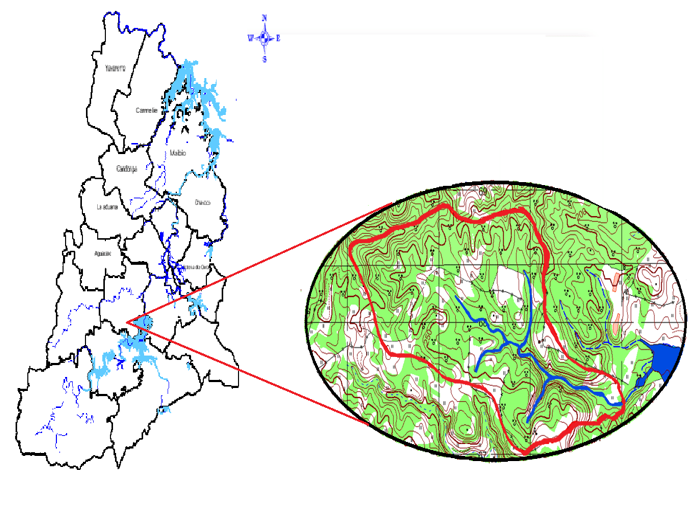
Ordenamento do território, na microbacia de Santa Rita, município de Palma Soriano
##plugins.themes.bootstrap3.article.sidebar##
##plugins.themes.bootstrap3.article.main##
Resumo
To generate correct and fair management of hydrographic basins, different perspectives and analyzes must be integrated, with a multidisciplinary vision and a systems approach. The fundamental objective of this work is to propose an organization of the areas in the Santa Rita micro-basin, based on the use of the soil, for its protection and sustainable management, and the awareness of the inhabitants of the area to preserve the resources of this ecosystem. A map was made in a GIS with the proposal to organize the use of land, where it was determined that there were 25 plots, with 52.91 hectares in conflict of use, 14 of them with overexploitation, and 11 underused. To organize these conflicts, it was defined that: 25.45 hectares will be allocated to agroforestry systems; 14.12 ha to fruit forests, 2.01 ha to temporary crops, 6.76 ha to coffee cultivation, and 4.57 ha to catchment basin protection forest. The source of employment, areas for food production, and the forested area and biodiversity of this ecosystem are increased.
Downloads
##plugins.themes.bootstrap3.article.details##

Este trabalho encontra-se publicado com a Creative Commons Atribuição-NãoComercial 4.0.
Referências
ACEVES NAVARRO, L.A., RIVERA HERNÁNDEZ, B., LÓPEZ CASTAÑEDA, A., PALMA LÓPEZ, D.J., GONZÁLEZ MANCILLAS, R., JUÁREZ LÓPEZ, J.F., ACEVES NAVARRO, L.A., RIVERA HERNÁNDEZ, B., LÓPEZ CASTAÑEDA, A., PALMA LÓPEZ, D.J., GONZÁLEZ MANCILLAS, R. y JUÁREZ LÓPEZ, J.F., 2018. Áreas potenciales y vulnerabilidad del cultivo de café tipo robusta (Coffea canephora P.) al cambio climático en el estado de Tabasco, México. Nova scientia [en línea], vol. 10, no. 20, [consulta: 12 abril 2024]. ISSN 2007-0705. DOI 10.21640/ns.v10i20.1379. Disponible en: http://www.scielo.org.mx/scielo.php?script=sci_abstract&pid=S2007-07052018000100369&lng=es&nrm=iso&tlng=es.
BERA, A., MUKHOPADHYAY, B.P. y DAS, D., 2018. Analysis of Adula River Basin in Maharashtra, India using GIS and Remote Sensing techniques. Geo-spatial Data in Natural Resources, DOI http://dx.doi.org/10.21523/gcb5.1702.
GEOCUBA, 2020. Mapa digital a escala 1:25 000 del catastro rural de Palma Soriano. 2020. S.l.: GEOCUBA.
HERNÁNDEZ-JIMÉNEZ, A., PÉREZ-JIMÉNEZ, J.M., BOSCH-INFANTE, D. y CASTRO SPECK, N., 2019. La clasificación de suelos de Cuba: énfasis en la versión de 2015. Cultivos Tropicales [en línea], vol. 40, no. 1, [consulta: 12 abril 2024]. ISSN 1819-4087. Disponible en: https://ediciones.inca.edu.cu/index.php/ediciones/article/view/1504.
LÓPEZ, M.Z.F., VENZOR, J.A.P. y AMAO, S.M., 2020. Diagnóstico hidrológico y ordenación de la Cuenca San Juan en Baja California Sur, México. Agronomía & Ambiente [en línea], vol. 39, no. 2, [consulta: 12 abril 2024]. ISSN 2344-9039. Disponible en: http://agronomiayambiente.agro.uba.ar/index.php/AyA/article/view/95.
REYES, O.J., 2011. Clasificación de la vegetación de la Región Oriental de Cuba. Revista del Jardín Botánico Nacional [en línea], vol. 32/33, [consulta: 12 abril 2024]. ISSN 0253-5696. Disponible en: https://www.jstor.org/stable/23725915.
REYES, O.J., CANTILLO, F.A. y GARRIDO3, P.B., 2022. Maturity mountain rainforest syntaxa from Sierra Maestra, Eastern Cuba. Revista Politécnica [en línea], vol. 18, no. 36, [consulta: 12 abril 2024]. ISSN 1900-2351, 2256-5353. Disponible en: https://www.redalyc.org/articulo.oa?id=607872732004.
ROA, C.C., DÁVILA, A.G.C., MÁRQUEZ, J.A.L. y CABEZAS, Y.O. de, 2020. Identificación de conflictos de uso de la tierra y propuesta de uso conservacionista en la subcuenca quebrada Mejías, municipio Antonio Pinto Salinas, estado Mérida, Venezuela. Revista de Topografía AZIMUT [en línea], vol. 11, no. 1, [consulta: 12 abril 2024]. ISSN 2346-1055. Disponible en: https://revistas.udistrital.edu.co/index.php/azimut/article/view/15979.
RODRÍGUEZ PECES, M.J. y GORDÓN PÉREZ, D., 2015. Análisis automático de la susceptibilidad de las inestabilidades de laderas provocadas por terremotos en un sector de la cordillera de los Andes, Ecuador. Revista de la Sociedad Geológica de España [en línea], vol. 28, no. 1, [consulta: 12 abril 2024]. ISSN 0214-2708. Disponible en: https://dialnet.unirioja.es/servlet/articulo?codigo=6304565.