Revista Cubana de Ciencias Forestales. May-August, 2019, 7(2): 263-275![]()
Translated from the original in spanish
Chemical properties of the soils in the semideciduous mesophilic forest of the Agroforestry Experimental Station of Guisa, Cuba
Propiedades químicas de los suelos en el bosque semideciduo mesófilo de la Estación Experimental Agroforestal de Guisa, Cuba
Alianna Corona Rodríguez1
1Universidad de Granma. Granma, Cuba. E-mail: acoronar@udg.co.cu
Received: March 11 th, 2019.
Approved: May 21 th, 2019.
ABSTRACT
The study was carried out in a fragment of the mesophilic semideciduous Forest of the Guisa Agroforestry Experimental Station, with the objective of chemically characterizing the forest floor along a profile. In its three transects were drawn in the sense of the toposequence (base, slope and summit). In each transect 9 samples were taken (from 0-20 cm) for their chemical analysis. Multiple means comparison tests were applied, through the Tukey HDS test (α= 0,05 %). Likewise, a linear regression analysis was developed and a correspondence analysis was carried out, in order to evaluate the interrelations among the chemical variables of the soil. The results indicated soils with high base saturation, low acidity and high concentration of Ca, especially at the slope and top levels. Brown soils with carbonates were identified in the base, and red Fersialitic and Redzina in the slope and the top. The Ca and P elements showed the greatest differences in the three topographic levels.
Keywords: fersialitic; profile; toposequence; vegetation.
RESUMEN
El estudio se realizó en un fragmento del bosque semideciduo mesófilo de la Estación Experimental Agroforestal de Guisa, con el objetivo de caracterizar químicamente el suelo del bosque a lo largo de un perfil. En el mismo se trazaron tres transectos en el sentido de la toposecuencia (base, ladera y cima). En cada transecto se tomaron 6 muestras (desde 0- 20 cm) para su análisis químico. Se aplicaron pruebas de comparación múltiple de medias, a través de la prueba de HDS Tukey (α= 0,05 %). De igual manera, se procedió a realizar un Análisis de regresión lineal y se realizó un análisis de correspondencia, con el fin de evaluar las interrelaciones entre las variables químicas del suelo. Los resultados indicaron suelos con alta saturación de bases, baja acidez y alta concentración de Ca especialmente en los niveles ladera y cima. Se identificaron suelos Pardos con carbonatos en la base, y Fersialítico rojo y Redzina en la ladera y la cima. Los elementos Ca y P fueron los que mostraron mayores diferencias en los tres niveles topográficos.
Palabras clave: fersialítico; perfil; toposecuencia; vegetación.
INTRODUCTION
Climatic aspects determine the type of vegetal formation that characterizes a site, but soil also significantly influences this distribution. In fact, hydrological changes are known to provide the development of different vegetal communities, which are closely related to drastic variations in soil types (Herrera, 2007).
In this sense, given the need to emphasize the factors that are involved in soil properties, from the chemical point of view, it is necessary to stress the behavior of the characteristics, under different soil uses, since the understanding of the chemical behavior of the soil under this analysis, becomes an essential instrument, which permits to assess its state (Arteaga et al., 2016).
Soil is a resource that can be considered non-renewable; it is very valuable because it provides sustenance for ecosystems and human life. Different kinds of soils have different behaviours depending on their physical, chemical and biological characteristics, and it is possible to establish correlations with Ziadat vegetation (2007); Carvalho, (2014).
Soil-vegetation and soil-landscape relationships are highly complex, because variation in soil properties within a region can be a consequence of topographic heterogeneity (Thiers et al., 2014).
The tropical dry caducifolia forests at the Guisa Agroforestry Experimental Station correspond to a region with little economic development and social abandonment, which implies a great compromise of the academic community with the restoration, conservation and use of natural resources for the benefit of the population, but in a context in harmony with nature.
In Cuba, recent studies have been carried out on this environmental component, to guarantee the distribution of species in the forest and achieve adequate management and sustainability of the main land ecosystems. Based on this, the present work proposes the objective of chemically characterizing the soil.
MATERIALS AND METHODS
Characterization of the Guisa Agroforestry Experimental Station forest
The forest under study is part of the forest heritage of the Experimental Forest Station "Guisa", in the municipality of Guisa, province of Granma. It has an area of 315.95 ha and is located at 200 0' 14'' N and 760 0' 30'' W, (cartographic sheet NO.4876-Ib) (Rodríguez et al., 2004) (Figure 1). Annual rainfall of 1,332.88 mm is reported in the area occupied by this forest, and the average annual temperature reaches 30.53 0C. The topography of the elevation presents a mountainous relief with a maximum altitude of 374 msnm, which sustains, according to the floristic structure, the forest formation Semiaducifolio Forest on limestone soils, according to Bisse, (1988) and Rodriguez et al., (2004). In this vegetal formation many canopy trees lose their leaves during the drought period (November-April), becoming critical during the months of February, March and April (Herrera, 2007).
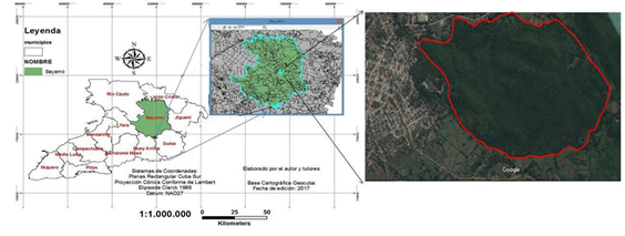
Fig. 1 - Geographical location of the study area
Sample design and sample size
The study area was stratified according to criteria of vegetation (dominant species, physiognomy, etc.), geographical and topographical, which allow it to be subdivided into homogeneous units in terms of relief, topography, soil and floristic structure (Matteucci and Colma, 2002).
Soil sampling
The characterization of the soil was done from morphological analysis in the field from the description and sampling of calicates, where the value of the slope was taken into consideration (using a clinometer) the shape of the slope was described (top, slope, base) and finally in the slope the position of the landscape was named (linear, concave, convex) where they are developed (Rodríguez et al., 2016).
Soil profiles were done by digging wells with boreholes at depths between 0-20 cm, taking into account the observable physical characteristics, and located in sites that showed the most representative characteristics (plant curvature, slope and avoiding trails) for each transect. The 18 samples (six in each transect) were collected in resistant and clean polyethylene bags, taking care not to contaminate or mix different samples. They were hermetically closed, labelled with a permanent marker and sent to the laboratory of the Provincial Soil of Granma.
Statistical analysis
Soil variables such as pH in water, macronutrients (Ca, Mg, K and Na) and total phosphorus were considered. A Tukey HDS test (α=0.05 %) was carried out, with a null hypothesis of no relation between matrices and with 99 permutations. This test evaluated significance. The results obtained were subjected to Chi² tests to compare these observed and expected values. Multiple mean comparison tests were applied, because the independent variables represented combinations of unstructured qualitative treatments (transects) with quantitative treatment (topographic level). All data were processed in the statistical program SPSS v.21 for Windows.
RESULTS AND DISCUSSION
The variability of macronutrients present in soils was not so significant (Figure 2), only calcium (Ca) presented greater variability and high soil contents. (Table 1).
For Ca, the average value was 58.73 Cmol c /Kg for the three levels. At the base the lowest values were reported to fluctuate between (45 - 47 Cmol c /Kg), at the slope were the highest (69 - 71 Cmol c /Kg) and at the top (55 - 66 Cmol c /Kg). The averages showed significant differences.
Table 1. - Differences in Ca values at topographic levels
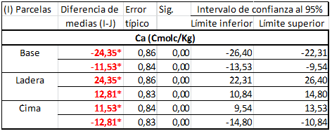
(*. The difference in averages is significant α= 0.05 %)
The pH was presented in slightly alkaline levels (7.0) to moderately alkaline levels (8.0), however, the averages of the three levels did not present significant differences between them, this can favor the mobility of ions, the precipitation and dissolution of minerals, the redox reactions, the ionic exchange, the microbial activity and the availability of nutrients. Although, it can become unfavorable for the solubility of organic matter as shown by Torres, Esquivel and Tinoco, (2017), (Table 2).
Table 2. - Differences in average values of P2 O5 and pH at topographic levels
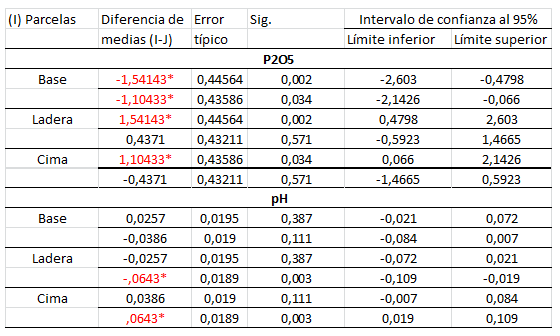
(*. The difference in averages is significant α= 0.05 %)
Phosphorus also has negative correlations with pH in water, indicating that the reactions that control the availability of this nutrient are related to the presence of cations in soil solution, mainly in soils with high contents of interchangeable bases. When the pH is between 6 and 10 the retention of phosphorus in the soil is mainly due to precipitation of calcium and magnesium phosphates (Fontana et al., 2006).
Similar studies state that the great majority of tropical soils present acid pH, determined by phenomena of intense washing as a consequence of the high precipitations (Alves and Paz, 2003; Jiménez et al.,2008). Schoenholtz et al., (2000), stressed that soil pH influences several chemical and biological processes simultaneously; therefore, it is always determined in soil fertility analyses. In addition, the high basicity of soils is directly related to the high concentration of phosphorus, indicating soils of high fertility.
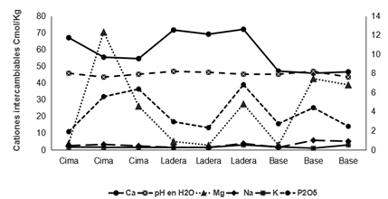
Fig. 2 - Macronutrient content in soil samples
As shown in Figure #2, magnesium (Mg) reported base values between 0.4-6.7 cmol/kg, on the slope ranged between 0.8 and 4.7 cmol/kg, while the top had the highest values (0.6-12.3 cmol/kg). The concentration of Mg at the base comes from minerals such as biotite, hornablende and chlorite from the volcanic rocks found in the area, however, on the slope and top the values are from mineral dolomite which is chemically composed of calcium carbonate. (Figure 2)
In relation to sodium (Na) an average of 0.52 cmol/kg was found, with a higher value of 0.99 cmol/kg at the base, and a lower value on the slope (0.25 cmol/kg). Potassium (K) averaged 0.3 cmol/kg although it was reduced to 0.25 cmol/kg at the top and was greater than 0.51 cmol/kg at the slope and base.
Phosphorus (P2O5) showed great variations among levels. The base showed a maximum value of 4.0 mg/100g and a minimum of 2.4 mg/100g. The hillside had a maximum value of 6.8 mg/100g and a minimum of 2.3 mg/100g and at the top the maximum value of 6.3 mg/100g and a minimum of 1.8 mg/100g. The mean value was 3.9 mg/100g. The values expressed above presented significant differences in relation to the three levels studied (Table 2).
The analysis of total phosphorus gives us a measure of the amount of phosphorus that a plant can use in the period of its growth because the phosphor is firmly retained by the soils and depends on the properties of these that the work of the roots on the phosphoric components of these.
Figure #3 shows the variability of calcium at the three topographic levels. The lowest values were at the base because the type of rock present at this level belongs to the volcanic rocks, which could be carbonated, because, although lower than the other levels are still high. In cases of slope and summit, higher values were found due to the presence of crystalline limestones and dolomites, where calcium is deposited in the form of insoluble carbonate, but also appears in the form of small crystals (Figure 3).
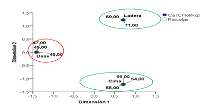
Fig. 3 - Representation of the relationship between Ca concentrations and topographic levels
The nine soil samples presented an ABC profile with similar characteristics on slope and top, however, lower macronutrient values were found at the base despite very similar pH values between topographic levels.
Rasmussen et al., (2010) reports that cations in solution are transported and increase their concentration from upper to lower positions, because due to water leaching, they accumulate in the lower part, however, the results reveal the opposite that as the topographic position increases the base concentrations also increase (Ca, Mg, K, Na). This is associated with the presence of different types of rocky material in the toposequence, on the summit and slope we find limestones, which when subjected to fractionation and in situ weathering causes chemical and mineralogical alteration in the soil, concentrating calcium and magnesium to a greater extent (Daly et al., 2015).
ABC profile soils at the base
Figure #4 shows an AB horizon of moderate development. The AB horizons have brownish colorations, granular structure and well-developed blocks in some cases. These are calcareous soils, generally with moderate amounts of CaCO3. According to this the pH is high, exceeding the value of 8 in water and 7.2 in KCl. These are developed on volcanic rocks of the Sabaneta formation. Therefore, applying what is established in the Classification of soils in Cuba, in the Base they correspond to the grouping of brown soils, Pardo genetic type (Hernández, 2015)
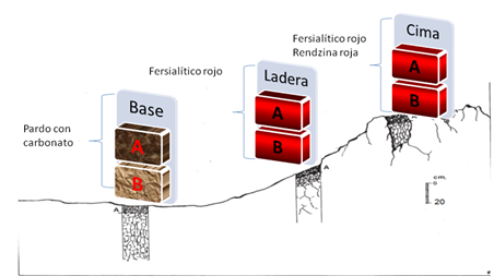
Fig. 4 - Soil types present in the studied surface
ABC profile soils on slope and top
The results of soil chemical analysis reveal that Ca is the dominant cation. The cation exchange capacity (CIC) is generally high on horizons A and B and is reddish in colour. Therefore, applying what is established in the Classification of the soils of Cuba, in slope and top it corresponds to Fersialíticos soils of red Fersialítico type and humic sialíticos soils of red red redzina type (Hernández, 2015).
This is due to the fact that at the base it is not the same type of soil as on the slope and summit, because according to the stratigraphic lexicon, the study surface is represented by the round puddle formation, which presents a lithology of compact organodetritic limestones, fossiliferous, of variable colour, predominantly white to grey-green tones, such as those found on the slope and summit. In the lower part of the cut, breccias are frequent, where thick stratification predominates, while in the upper part fine stratification predominates, presenting a Middle Eocene age (Collective of authors, 2013).
It lies concordantly on the Sabaneta Formation, which presents a lithology of calcareous tufites, tobaceous sandstones, limestones, marlstones and occasionally small bodies of basalts, andesites, andesite-basalts andesite-diazites, these we find at the base. However, according to Coutrim et al. (2012), the relative position of soils on the slope has a greater influence on soil behaviour than the original material itself. On the other hand, in soils of volcanic origin it is remarkable the textural combination that provides frequently homogeneous mineral distributions, with the action of elements such as Mg and Ca that act on their mobility and stability (Cuadros et al., 2016).
The macronutrients that are present behave in a high way, with Ca being the main cation. The washing of the calcium bicarbonate will be contributed by the topographic position, the coarse texture and the scarce thickness of the soils, this is due to the abundant precipitations that are registered in the zone, being deposited in the low part. Because Ca exists as a cation, this nutrient is governed by the phenomena of cation exchange like the other cations, and remains attached as interchangeable Ca++ on the surface of negatively charged colloids. It is generally the dominant cation in the soil, even at low pH values.
In the case of the soils on the slopes and top, the presence of considerable amounts of carbonates in these soils (as opposed to those at the base) is justified both by their location in receptive areas, where the contribution of limestone in elements of various sizes is opposed to decarbonation, and by the proximity of the starting material that involves a carbonate reserve much more accessible than a coherent rock. These data agree with that expressed by Taboada et al., (2016). Therefore, it can be affirmed that the topographic position is the main conditioner of the development of the profiles and therefore the differentiating factor of the types of soils, agreeing with what is expressed by Taboada et al., (2016).
The above is in agreement with that expressed by Mello (2006) that Ca, because it has greater valence ions and larger when hydrated, is adsorbed with greater bond energy for soil charges, such as the liotrophic series, which influence the availability of Mg, P and K. In addition to the chemical aspects influenced by Ca, this is the nutrient that is the most aggregated effect in the soil, which favors the permeability and infiltration of water, which affects the development of the root system of plants.
High pH values in soils favour the precipitation of phosphorus (P). Soils generally contain less Mg than Ca because Mg is not absorbed as strongly as Ca by soil colloids and can be lost more easily by leaching.
In the soils of the study area there are high contents of interchangeable bases and the predominant pH oscillates between neutral and basic. The classification of the same evidences three well represented genetic types (Brown, Red Fersialithic). The topography favours in situ chemical meteorisation of the rocks causing high concentrations of elements such as calcium and magnesium on the slope and top of the toposequence.
BIBLIOGRAPHICAL REFERENCES
ALVES, M. y PAZ, J., 2003. Variabilidad en el pH de un suelo decapitado sometido a diferentes tratamientos de recuperación. IX Conferencia Española de Biometría: 3-4. La Coruña, España.
ARTEAGA J., J.C., NAVIA ESTRADA, J.F. y CASTILLO FRANCO, J.A., 2016. Comportamiento de variables químicas de un suelo sometido a distintos usos, departamento de Nariño, Colombia. Revista de Ciencias Agrícolas [en línea], vol. 33, no. 2, pp. 62-75. [Consulta: 2 abril 2019]. ISSN 2256-2273, 0120-0135. Disponible en: https://dialnet.unirioja.es/servlet/articulo?codigo=5763145
BISSE, J., 1988. Árboles de Cuba. Ciudad de la Habana: Editorial Ciencia y Técnica.
CARVALHO SPANNER, G., SANTOS DAS NEVES, É., COELHO DO NASCIMENTO, J., COSTA MILÉO, J.A. y SANTOS DA SILVA, S.A., 2014. DETERMINAÇÃO DOS ASPECTOS MORFOLÓGICOS DO SOLO E DENDROLÓGICOS DA VEGETAÇÃO EM UMA TOPOSSEQUÊNCIA, E M ALTAMIRA-PA. Centro Científico Conhecer - Goiânia [en línea], vol. 1, no. 2. Disponible en: http://docplayer.com.br/10992913-Determinacao-dos-aspectos-morfologicos-do-solo-e-dendrologicos-da-vegetacao-em-uma-topossequencia-em-altamira-pa-para-ufpa-campus-de-altamira.html.
COLECTIVO DE AUTORES., 2013. Léxico estratigráfico de Cuba. La Habana, Cuba: Instituto de Geología y Paleontología.
CUADROS, J., DIAZ-HERNANDEZ, J.L., SANCHEZ-NAVAS, A., GARCIA-CASCO, A. y YEPES, J., 2016. Chemical and textural controls on the formation of sepiolite, palygorskite and dolomite in volcanic soils. Geoderma [en línea], vol. 271, pp. 99-114. [Consulta: 2 abril 2019]. ISSN 0016-7061. DOI 10.1016/j.geoderma.2016.01.042. Disponible en: http://www.sciencedirect.com/science/article/pii/S0016706116300428.
DALY, K., STYLES, D., LALOR, S., WALL, D. P., 2015. Phosphorus sorption, supply potential and availability in soils with contrasting parent material and soil chemical properties. European Journal of Soil Science, 66(4), 792-801.
HERNÁNDEZ, A., PÉREZ, J.M., BOSCH, D. y CASTRO, L., 2015. Clasificación de los Suelos de Cuba. Mayabeque, Cuba: Ediciones INCA.
HERRERA, P., 2007. Flora y vegetación. En: H. GONZÁLEZ (ed.), Biodiversidad de Cuba. La Habana, Cuba: Ediciones Polymita, pp. 142.
JIMÉNEZ, L.S., MEZQUIDA, E.T., BENITO CAPA, M. y RUBIO SÁNCHEZ, A.,2008. Fertilidad del suelo de bosques tropicales y pastizales de uso ganadero en el sur del Ecuador. Cuadernos de la Sociedad Española de Ciencias Forestales [en línea], vol. 25, pp. 241-245. [Consulta: 2 abril 2019]. ISSN 1575-2410. Disponible en: http://oa.upm.es/48546/.
MATTEUCCI, S. D. y COLMA, A., 2002. Metodología para el estudio de la vegetación [en línea]. Washington, D. C.: Secretaría General de la Organización de los Estados Americanos. Programa Regional de Desarrollo Científico y Tecnológico. [Consulta: 2 abril 2019]. serie de Biología, Monografía no.22. Disponible en: https://www.researchgate.net/publication/44553298_Metodologia_para_el_estudio_de_la_vegetacion_por_Silvia_D_Matteucci_y_Aida_Colma.
MELLO, N.A., 2006. Efeito do sistema de manejo nos atributos do solo, movimentação de sedimentos e exportação de carbono orgânico numa microbacia rural sob cultura do fumo. 248p. Tese de Doutorado. Porto Alegre, Universidade Federal do Rio Grande do Sul.
PATURLANE, M., SAKS, M. y QUIROGA, A., 2006. Efecto del espesor de suelo sobre propiedades edáficas y rendimiento de trigo en la región semiárida pampeana. En: F. FONTANA, Aspectos de la evaluación y el manejo de los suelos en la región semiárida pampeana. Física de suelos [en línea]. S.l.: EEA INTA Anguil, Public.Técn. N°66, pp. 15-22. Disponible en: https://inta.gob.ar/documentos/aspectos-de-la-evaluacion-y-el-manejo-de-los-suelos-en-la-region-semiarida-pampeana-1.
RASMUSSEN, C., DAHLGREN, R., SOUTHARD, R.J., 2010. Basalt weathering and pedogenesis across an environmental gradient in the southern Cascade Range. California.USA. Geoderma 154, 473-485.
REYES, J., GERDING, V. y SCHLATTER, J.E., 2014. Suelos en ecosistemas forestales. En: O. THIERS, Ecología forestal. Bases para el manejo sustentable y conservación de los bosques nativos de Chile [en línea]. Valdivia, Chile: Ediciones UACh, pp. 133-178. ISBN 978-956-9412-06-6. Disponible en: http://www.edicionesuach.cl/index.php/coleccion-patrimonio-institucional/22-ecologia-forestal-donoso-gonzalez-lara.
RODRÍGUEZ SOSA, J.L., GUEVARA SANCHEZ, M.A. y SANTANA NÚÑEZ, M.F., 2004. Estudio Florístico del bosque de la Estación forestal Guisa. Granma. Revista Tatascán [en línea], vol. 5, no. 11, pp. 15-21. Disponible en: https://docplayer.es/49246531-Estudio-floristico-del-bosque-de-la-estacion-experimental-forestal-guisa-granma.html.
SANTOS, L.A.C. dos, CAMPOS, M.C.C., COSTA, H.S. y PEREIRA, A.R., 2012. Caracterização de solos em uma topossequência sob terraços aluviais na região do médio rio Madeira (AM) Characterization of soils in a toposequence under alluvial terraces in the middle rio Madeira (AM). AMBIÊNCIA [en línea], vol. 8, no. 2, pp. 319-331. [Consulta: 2 abril 2019]. ISSN 2175-9405. Disponible en: https://200.201.10.18/index.php/ambiencia/article/view/1444.
SCHOENHOLTZ, S.H., MIEGROET, H.V. y BURGER, J.A., 2000. A review of chemical and physical properties as indicators of forest soil quality: challenges and opportunities. Forest Ecology and Management [en línea], vol. 138, no. 1, pp. 335-356. [Consulta: 2 abril 2019]. ISSN 0378-1127. DOI 10.1016/S0378-1127(00)00423-0. Disponible en: http://www.sciencedirect.com/science/article/pii/S0378112700004230.
TABOADA, T., RODRÍGUEZ-LADO, L., FERRO-VÁZQUEZ, C., STOOPS, G. y MARTÍNEZ CORTIZAS, A., 2016. Chemical weathering in the volcanic soils of Isla Santa Cruz (Galápagos Islands, Ecuador). Geoderma [en línea], vol. 261, pp. 160-168. [Consulta: 2 abril 2019]. ISSN 0016-7061. DOI 10.1016/j.geoderma.2015.07.019. Disponible en: http://www.sciencedirect.com/science/article/pii/S0016706115300288.
TORRES-BENÍTEZ, A.J., ESQUIVEL, H.E. y TINOCO, F., 2017. Composición física y química de los suelos fluviovolcánicos de Armero Tolima, Colombia. Revista de la Academia Colombiana de Ciencias Exactas, Físicas y Naturales [en línea], vol. 41, no. 158, pp. 119-126. [Consulta: 2 abril 2019]. ISSN 2382-4980. DOI 10.18257/raccefyn.447. Disponible en: https://www.raccefyn.co/index.php/raccefyn/article/view/447.
ZIADAT, F.M., 2007. Land suitability classification using different sources of information: Soil maps and predicted soil attributes in Jordan. Geoderma [en línea], vol. 140, no. 1, pp. 73-80. ISSN 0016-7061. DOI 10.1016/j.geoderma.2007.03.004. Disponible en: http://www.sciencedirect.com/science/article/pii/S0016706107000730
.
![]()
This work is licensed under a Creative Commons Attribution-NonCommercial 4.0 International license
Copyright (c) 2019 Alianna Corona Rodríguez